


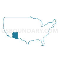
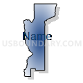
Mohave & La Paz Counties--Lake Havasu City PUMA, Arizona
About
Outline

Summary
| Unique Area Identifier | 192166 |
| Name | Mohave & La Paz Counties--Lake Havasu City PUMA |
| State | Arizona |
| Area (square miles) | 17,974.40 |
| Land Area (square miles) | 17,810.71 |
| Water Area (square miles) | 163.69 |
| % of Land Area | 99.09 |
| % of Water Area | 0.91 |
| Latitude of the Internal Point | 35.20177810 |
| Longtitude of the Internal Point | -113.82954470 |
Maps

Graphs
Select a template below for downloading or customizing gragh for Mohave & La Paz Counties--Lake Havasu City PUMA, Arizona


Neighbors
Neighoring Public Use Microdata Area (by Name) Neighboring Public Use Microdata Area on the Map
- Clark County (East)--Mesquite City, Sunrise Manor (North), Moapa Valley & Nellis AFB PUMA, NV
- Clark County (South)--Henderson (East) & Boulder Cities PUMA, NV
- Coconino County--Flagstaff City PUMA, AZ
- Imperial County--El Centro City PUMA, CA
- Maricopa County (West) & Gila River Indian Community (Northwest) PUMA, AZ
- Riverside County (East)--Indio, Coachella, Blythe & La Quinta (East) Cities PUMA, CA
- Rural Nevada PUMA, NV
- San Bernardino County (Northeast)--Twentynine Palms & Barstow Cities PUMA, CA
- Southwest & South Central Utah (Outside Washington County)--Cedar City PUMA, UT
- Washington County--St. George City PUMA, UT
- Yavapai County PUMA, AZ
- Yuma County--Yuma City PUMA, AZ
Top 10 Neighboring County (by Population) Neighboring County on the Map
- Maricopa County, AZ (3,817,117)
- Riverside County, CA (2,189,641)
- San Bernardino County, CA (2,035,210)
- Clark County, NV (1,951,269)
- Yavapai County, AZ (211,033)
- Mohave County, AZ (200,186)
- Yuma County, AZ (195,751)
- Imperial County, CA (174,528)
- Washington County, UT (138,115)
- Coconino County, AZ (134,421)
Top 10 Neighboring County Subdivision (by Population) Neighboring County Subdivision on the Map
- Clark CCD, Clark County, NV (179,324)
- Yuma CCD, Yuma County, AZ (138,997)
- Prescott CCD, Yavapai County, AZ (119,809)
- St. George CCD, Washington County, UT (110,091)
- Wickenburg CCD, Maricopa County, AZ (93,175)
- Kingman CCD, Mohave County, AZ (66,268)
- Bullhead City CCD, Mohave County, AZ (65,938)
- Buckeye CCD, Maricopa County, AZ (62,196)
- Lake Havasu City CCD, Mohave County, AZ (57,129)
- Hurricane CCD, Washington County, UT (25,701)
Top 10 Neighboring Place (by Population) Neighboring Place on the Map
- St. George city, UT (72,897)
- Lake Havasu City city, AZ (52,527)
- Bullhead City city, AZ (39,540)
- Kingman city, AZ (28,068)
- Blythe city, CA (20,817)
- Mesquite city, NV (15,276)
- Fort Mohave CDP, AZ (14,364)
- New Kingman-Butler CDP, AZ (12,134)
- Golden Valley CDP, AZ (8,370)
- Laughlin CDP, NV (7,323)
Top 10 Neighboring Elementary School District (by Population) Neighboring Elementary School District on the Map
- Yuma Elementary District, AZ (99,267)
- Bullhead City School District, AZ (40,144)
- Mohave Valley Elementary District, AZ (21,720)
- Quartzsite Elementary District, AZ (6,162)
- Wellton Elementary District, AZ (4,038)
- Salome Consolidated Elementary District, AZ (2,763)
- Topock Elementary District, AZ (2,500)
- Congress Elementary District, AZ (2,439)
- Mohawk Valley Elementary District, AZ (1,597)
- Arlington Elementary District, AZ (1,472)
Top 10 Neighboring Secondary School District (by Population) Neighboring Secondary School District on the Map
- Yuma Union High School District, AZ (189,381)
- Buckeye Union High School District, AZ (65,817)
- Colorado River Union High School District, AZ (64,364)
- Bicentennial Union High School District, AZ (10,921)
- Antelope Union High School District, AZ (6,370)
Top 10 Neighboring Unified School District (by Population) Neighboring Unified School District on the Map
- Clark County School District, NV (1,951,269)
- Washington School District, UT (138,115)
- School District Not Defined, AZ (69,809)
- Kingman Unified School District, AZ (65,381)
- Lake Havasu Unified District, AZ (55,531)
- Palo Verde Unified School District, CA (24,294)
- Parker Unified School District, AZ (9,568)
- Saddle Mountain Unified School District, AZ (8,821)
- Kane School District, UT (7,125)
- Needles Unified School District, CA (7,087)
Top 10 Neighboring State Legislative District Lower Chamber (by Population) Neighboring State Legislative District Lower Chamber on the Map
- Assembly District 80, CA (546,875)
- Assembly District 34, CA (487,193)
- State House District 4, AZ (294,239)
- State House District 3, AZ (216,687)
- State House District 25, AZ (208,220)
- State House District 24, AZ (207,694)
- State House District 2, AZ (177,904)
- Assembly District 36, NV (59,012)
- Assembly District 20, NV (58,569)
- State House District 71, UT (51,723)
Top 10 Neighboring State Legislative District Upper Chamber (by Population) Neighboring State Legislative District Upper Chamber on the Map
- State Senate District 37, CA (1,215,876)
- State Senate District 18, CA (1,048,811)
- State Senate District 40, CA (1,018,606)
- State Senate District 4, AZ (294,239)
- State Senate District 3, AZ (216,687)
- Clark County Senatorial District 12, NV (214,362)
- State Senate District 25, AZ (208,220)
- State Senate District 24, AZ (207,694)
- State Senate District 2, AZ (177,904)
- State Senate District 29, UT (120,802)
Top 10 Neighboring 111th Congressional District (by Population) Neighboring 111th Congressional District on the Map
- Congressional District 3, NV (1,043,855)
- Congressional District 2, AZ (972,839)
- Congressional District 45, CA (914,209)
- Congressional District 2, UT (890,993)
- Congressional District 7, AZ (855,769)
- Congressional District 2, NV (836,562)
- Congressional District 41, CA (797,133)
- Congressional District 1, AZ (774,310)
- Congressional District 51, CA (757,891)
Top 10 Neighboring Census Tract (by Population) Neighboring Census Tract on the Map
- Census Tract 2708.01, Washington County, UT (13,516)
- Census Tract 9501, Mohave County, AZ (10,851)
- Census Tract 2709.02, Washington County, UT (10,113)
- Census Tract 9506, Mohave County, AZ (9,029)
- Census Tract 9536.01, Mohave County, AZ (8,853)
- Census Tract 2701, Washington County, UT (8,839)
- Census Tract 2703, Washington County, UT (8,148)
- Census Tract 9520.02, Mohave County, AZ (7,439)
- Census Tract 9548, Mohave County, AZ (7,012)
- Census Tract 9539, Mohave County, AZ (6,696)
Top 10 Neighboring 5-Digit ZIP Code Tabulation Area (by Population) Neighboring 5-Digit ZIP Code Tabulation Area on the Map
- 85365, AZ (46,558)
- 84790, UT (35,770)
- 86442, AZ (33,382)
- 86409, AZ (26,471)
- 92225, CA (24,310)
- 86401, AZ (24,289)
- 86406, AZ (23,763)
- 86305, AZ (17,356)
- 86404, AZ (16,243)
- 86403, AZ (15,802)